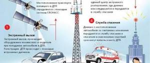
The manufacturer equips its LADA vehicles with an emergency response system in case of accidents “ERA GLONASS” or (SVEOS). The control unit is built into the navigation light on the ceiling and has several rows of buttons. Let's consider the capabilities of this system in more detail.
Disabling the Glonass Era on Vesta - the treasured SOS button
Is it possible to get rid of Glonass tracking? Let’s try to give an accurate and reasoned answer. But understand that you will carry out this work only at your own peril and risk. Lada Vesta is one of the first Russian cars that received such a system already in the “base”; all trim levels are equipped with it from the factory. You can argue for a long time about the benefits or harm of the option. The mission of this option is as follows:
In the event of an accident, the device sends geolocation data to the control room, from where the information is transmitted to emergency services.
When you press the button, the operator is dialed; the device has a SIM card. This is manual mode. In automatic mode the pump will work:
- From airbag deployment;
- Triggering of the accelerometer sensor;
- Automatic mode recognizes several types of accidents:
- Side impact - if the car was hit from the side;
- Rear collision - a car coming from behind hit you;
- Car overturn - if the car has turned over.
After an accident or after pressing a button, the sos-system will connect with the operator and send additional information about the vehicle and the accident:
- car vin code,
- the speed at which it moved;
- impact damage: where the car is damaged, the color of the car;
- What kind of gasoline is it filled with?
If after an accident no one is able to press the button, then everything will go away on its own. Then the dispatcher will call the car and if no one answers, he will send help.
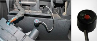
In addition to the sos button itself, the device has the following components:
- Microphone for communication;
- Speaker - to hear the operator;
- SIM card and modem - for communication with the Internet and operator;
- Accelerometer and gyroscope;
- GNSS/GSM antenna - communication amplifier;
- Module for GLONASS navigation.
It is clear that the whole sos button project has good intentions and can save lives.
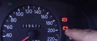
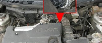
Suspicious Lada Vesta drivers are worried that they are being followed. You can simply turn off the SOS on the Lada Vesta by removing the power supply connector. However, be aware that the system has backup batteries, so to turn off Glonass completely, you will need to wait at least 48 hours.
How to make a mobile phone a tracking device
To track the location of an object, be it a car or your child's smartphone, you don't have to buy a tracker. By installing the “GPShome Tracker” mobile application, you can control the current position of the device.
So, GLONASS on the phone, how does the orientation program work? To transfer a data package, the Internet is required - Wi-Fi or a mobile network.
The connection algorithm is as follows:
1. Register on the developer's website. In the fields, write down your username and password, and enter your email address. Select the “Individual” checkbox and accept the user agreement. 2. A link will be sent to your email to activate your Personal Account. Go to the service and in the “Settings” window click “Add object”. Fill in the fields: “Name”; “Tracker IMEI” is the smartphone identifier; click “Save”. 3. In the smartphone settings, enable the “Location: satellite” option. 4. Download the utility from Google Play. 5. Open “Settings” and check the boxes “Enable tracker”, “Use network” and “Use GPS”. 6. For convenient use, the program is divided into three blocks: “Information”, “Maps”, “Settings”.
The first section shows the coordinates, the second section shows the current location. The application quickly eats up battery power, so disable it if not needed.
In the previous sections of the publication, we examined the question of what GLONASS is and why it is needed in a phone. Now let's see which models support the Russian and American groups.
The first phone that started receiving signals from our devices was the branded MTS Glonass 945. The smartphone ran Android 2.2 and had a 2 MP camera. In conversation mode the battery lasted 300 minutes. Sales started in March 2011, but were not successful. Having sold 5 thousand copies, ZTE, Sitronics and Qualcomm stopped production.
We present an overview of successful models of 2020 that can be ordered in online stores:
1. Let's start with the Samsung Galaxy S10+ phablet. The 6.4-inch screen is covered with protective glass Corning Gorilla Glass 6. Inside the flagship is an Exynos 9820 processor and 12 GB of RAM. The company equipped the smartphone with a record 1 TB of internal memory for storing files. In talk mode, the charge lasts 25 hours. 2. A more affordable option – Xiaomi Redmi 6A in a metal case. 5.4-inch display, 18:9 aspect ratio, HD resolution 1440x720. Works in 4G LTE cellular networks. The smartphone is controlled by the MediaTek Helio A22 chip. The main and front cameras are 13 and 5 megapixels. In addition to the indicated navigation systems, it receives the BeiDou signal. 3. The main highlight of the Russian smartphone YotaPhone 2 is its two screens. The front display is 5 inches, the back side is 4.7. Here you can find widgets for clock, weather, and notifications. One 8-megapixel camera works with two screens. 4. The operation of Huawei Honor 7A is controlled by the MediaTek MT6739 module and Android 8.1. Diagonal 5.45 inches with TFT matrix. “Catches” the signal of both systems, supports A-GPS for quick location determination. Battery capacity – 3020 mAh. The charge lasts a full day.
In conclusion, satellite navigation is a useful feature of modern phones. There is no need to buy extra devices, because this option is already built into the device.
The development of the Russian satellite navigation system, as in the case of the American GPS, began back in the 70s of the last century. GLONASS is an acronym for Global Navigation Satellite System. If a few years ago the bulk of its mentions were related to the launches of new satellites into orbit (both successful and not so successful) and jokes about this, then the state at the end of 2020 can be stated: GLONASS is working.
Which smartphones support GLONASS
The first smartphone to support the GLONASS navigation system was the Russian-Chinese model MTS 945, introduced in 2011. It did not gain popularity due to poor functionality and high cost. Other manufacturers did not waste time and began to build GLONASS receivers into their devices themselves. Since 2011, many products from Apple, Samsung, Xiaomi, Lenovo, Nokia and others have been equipped with support for the Russian navigation system.
The situation has been greatly simplified by the fact that most smartphone manufacturers do not develop and produce chipsets, radio modules and other high-tech components, but purchase ready-made chips from giants such as Qualcomm, Samsung or Mediatek. Therefore, when the next Exynos or Snapgragon chipset acquires GLONASS support, all devices built on its basis theoretically receive support for the Russian navigation system.
How to check GLONASS support
Unfortunately, the presence of theoretical support does not always mean such support in practice. Not everyone is in a hurry to realize the 100% potential of their product's hardware. This is often done in order to further emphasize the difference between budget and more expensive smartphones built on similar hardware. Therefore, to find out whether your device supports GLONASS, you need to install the free AndroiTS GPS Test Free program on your smartphone. It, as the name suggests, is designed to test the navigation capabilities of mobile technology.
By launching the program (with navigation turned on in the smartphone itself, of course) and being outdoors, you can watch how it finds navigation satellites. The satellites of the American GPS will be marked with the US Stars and Stripes, and the Russian GPS, respectively, with the tricolor. Of course, you don’t have to go outside, but it’s impossible to equip such a compact device as a smartphone with a powerful receiver. Many devices receive satellite signals very poorly through thick walls and ceilings.
How to use GLONASS
In order to use GLONASS, you do not need to perform any special actions. Most smartphone navigation software supports it by default. If such software is installed on your device out of the box, when launched it will automatically connect to both GLONASS and GPS satellites. If there is no navigation program on board, you can download the same GoogleMaps or Yandex.Maps from the market.
Why is this necessary?
The coverage of the satellites of both navigation systems today, although it is quite dense, it is impossible to ensure equally accurate location determination in different parts of the planet. In some places, GPS reception is better, in others - GLONASS. Maintaining communication with two systems at once allows you to reduce the number of “dead zones” where there is no reliable reception of one of them.
It is worth noting that GPS more correctly determines location in temperate and equatorial latitudes, where GLONASS is not highly accurate. At the same time, the Russian navigation system feels more confident in the northern regions of the planet. In any case, the combination of signals from both of them is definitely a plus.
mobcompany.info
What problems does satellite navigation solve? You need to know
How Glonass works is easy to understand by carefully reading the following paragraphs. The device, using navigation and several installed sensors and controllers, allows for optimization of work for a transport corporation or taxi. These special sensors are called counters. So, these meters are installed on the fuel system, interact with the “brains”, as a result, information about the vehicle is displayed before the eyes of the company owner.
It becomes possible to control consumption, but remotely; monitoring allows you to find out whether the driver is driving to the left or not. Fuel control is important for management, because often drivers are not averse to draining a certain amount of gasoline.
Navigation gives management an understanding of where the vehicle is, the time of movement, how the driver works, and so on. Based only on data on consumption, driving schedule, information about movement, it is possible to reduce the subjective factor. Responsibility increases, there are fewer leftists, they don’t break the rules, they don’t speed up the speedometer.
In addition, the vehicle’s condition, service life and operation are monitored. But all this is doable, taking into account the fact that the device itself is working and functioning correctly.
GLONASS in an Android smartphone: what is it and how does it work?
Vyacheslav Grishankov 11/15/2017 0
The presence of a navigator even in a budget smartphone today will not surprise anyone.
We are used to using GPS to find the desired address or to determine our location. GPS is an abbreviation for the English words Global Positioning System. This is the name of the very first and most famous satellite geopositioning system, which was developed in the USA. Since 2000, it has become available to the civilian population of all countries, although until that time it worked exclusively for military structures.
Its popularity is so great that in everyday life we still call the geolocation of our smartphones GPS, although we currently use signals from other systems - the Russian GLONASS and the Chinese Beidou. Today we will talk about GLONASS.
History of GLONASS
The development of GLONASS began in the Soviet Union in 1976, and in 1986 flight tests of the first satellites and their prototypes began. At the end of the 90s of the 20th century, this work was suspended due to lack of funding.
In 2001, the Russian Federation again set a course for launching its own navigation system, having adopted the federal program “Global Navigation System”. By 2010, the total number of GLONASS satellites in orbit was 26 - they provided complete coverage of the planet.
GLONASS in smartphones
Following the launch of full operation of GLONASS, the Russian cellular provider MTS introduced its smartphone of the same name in 2011, with an emphasis on supporting the domestic satellite system. The phone itself did not receive recognition, but well-known gadget manufacturers began to implement the ability to receive signals from Russian satellites.
Apple was the first to do this after MTS, followed by Nokia and Samsung. True, for the average user this remained almost unnoticeable, since most smartphones do not have buttons in the menu directly related to GLONASS. In most of them, turning on and configuring the satellite module began to be done through the “Geodata” menu item, while previously it was called “GPS”.
Navigation applications, when launched, began to detect more satellites with an available signal, and the accuracy of the location on the map has increased significantly. The process of searching for satellites has accelerated significantly.
GPS or GLONASS
Fortunately, in everyday life there is no need to make such a choice, since geopositioning in smartphones is determined by those satellites whose signal is stronger at a given time. When comparing these two geolocation systems, it will be difficult to say which one is better. If we evaluate the accuracy of location determination, then GPS makes it more reliable - the error is 1.5 meters, while for GLONASS it is 2.5 meters. But this indicator is relative, since it can change at different times and in different places.
As for the stability of signals, in northern latitudes GLONASS is ahead of GPS, since the American satellite system is focused on temperate and equatorial zones. In general, it is convenient that GPS and GLONASS work simultaneously in smartphones. As they say, one head is good, but two are better.
To find out which satellites we are in range of, we recommend installing one of the applications from Google Play, for example “GPS Info”, “GPS test” or “GPS Status”. They monitor available satellites, their number, names of satellite systems and signal strength.
Today the political situation in the world cannot be called stable. If the United States imposes a ban on the use of GPS, then we have an excellent alternative - the domestic GLONASS system.
(2 ratings, average: 3.50 out of 5)
androidlime.ru
How to jam Glonass on a car using artificial interference?
Satellite signal jammers are not difficult to find - there are many of them, but understand here that by jamming the signal, the map of your movements will not go anywhere. After the connection is restored, the data will be automatically sent.
The same goes for shielding. When the sensors are covered with special materials, the signal disappears, although only distant satellites are jammed. Even if there is no connection, the data is saved and sent as soon as a connection appears.
There are such ways to bypass control, but one cannot expect a significant and expected result from them. Keep in mind that actions aimed at causing damage or circumventing control are subject to administrative violation. Therefore, think before you deceive Glonass.
What is GLONASS in a smartphone and how does it work?
The abbreviation GLONASS stands for Global Navigation Satellite System. Not everyone knows that the official start of the development of GLONASS was laid back in 1976. In 2015, the completion of the GLONASS system was officially announced. The system is a competitor or, if you like, an analogue of another satellite navigation system - GPS (Global Positioning System).
Using GLONASS in a smartphone or telephone allows you to determine your location. The system is used, for example, in navigation programs used by many mobile device users.
How to find out if your smartphone has GLONASS?
To find out whether your device supports GLONASS, you can, for example, go to Yandex.Market and look at the characteristics for your smartphone. If it is indicated that GLONASS is supported, then it is. Just be careful: the manufacturer may produce several similar devices, some of which may have GLONASS support, while others will not.
In addition, you can find out about system support directly from the smartphone menu. To do this, go to the navigation system settings. If GLONASS is a separate item, it means that support for this navigation system is present.
Finally, you can install a program to test the navigation properties of your smartphone. You install it, launch it, go out into the open for a more accurate testing result, and wait a little while the application detects satellites. If your satellites include both GPS and GLONASS, congratulations—the device supports both navigation systems. GPS is usually indicated by an icon with an American flag, GLONASS - with a Russian flag.
Which smartphones support GLONASS?
Just a few years ago, you could count on your fingers the number of smartphones that supported GLONASS. Today everything has changed and you can find GLONASS in a huge number of devices, including iPhone or Samsung.
The fact that device manufacturers for the most part do not develop chipsets, but purchase them from other well-known companies, has also helped to significantly increase the share of smartphones with GLONASS support. The latter add both GPS support and GLONASS support to the chipsets. So very soon there will be no smartphones left that will not support GLONASS - as happened with GPS at one time.
Why do you need GLONASS and GPS at the same time in a smartphone?
It’s simple: in some places the positioning accuracy is better with GLONASS, in others with GPS, and in total both systems allow you to position the device more accurately, which, of course, is a big plus for the smartphone buyer.
For example, satellite systems are actively used in navigation applications. And the higher the positioning accuracy, the less likely it is that the driver will miss the desired turn.
How to use GLONASS?
Just like GPS. Turn on support for the satellite system, open the application with maps and work with them. If you don't have such an application, download it from Google Play Market, where you will find a lot of free applications for every taste.
androidnik.ru
Power off
Many people believe that there is no need to think about how to deceive GLONASS. After all, it’s enough just to turn off the system, then go about your business, and then turn on the device again. At the same time, such a solution has several disadvantages.
First of all, the dispatcher will receive a message that the device is disconnected from external power . In addition, the wire can only be pulled out by damaging the seal. Thus, everyone will know that GLONASS was disabled by the driver. As a result, the answer to the question: “What does turning off the power to the AutoGRAPH system lead to?” obvious: no use.
How to check GLONASS support
From the question of GLONASS in a smartphone - what is it, we move on to the next point: how to find out whether the phone supports the signal of the Russian constellation.
In this case, there are two options: go to the manufacturer’s website and study the characteristics of the model. Another way is to install an analyzer application for Android. Let's take a short overview of programs and functions:
1. “GPS-test” checks the supported system and measures the reception level. The utility displays the position of satellites in the sky, current location, speed and altitude. Geodata is transmitted by email or SMS. Records information in the form of diagrams and diagrams. 2. “GPS Status & Toolbox” will show which satellites the smartphone supports. 3. “GPS-Status Data” shows information about satellites, the signal quality of each of them. The program displays coordinates and time. To check which geolocation system works on your mobile phone: • open the “Location” section in “Settings”; • in the “Detection mode” item, check “By satellites”. • download any application from the list and run the scan.
In different applications, groups are marked with the colors of the national flag or shapes (triangle, square, polygon). If you see satellites marked with a tricolor or square, it means GLONASS is supported. If no system is detected during the test, repeat the procedure in an open area. It is possible that concrete floors are interfering with the signal.